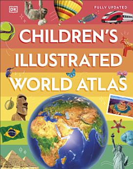
Children's Illustrated World Atlas
DK
2024年6月 · Dorling Kindersley Ltd
电子书
144
页
family_home
符合条件
info
report评分和评价未经验证 了解详情
关于此电子书
Take young readers on the ultimate round-the-world trip with this impressive atlas - packed full of beautiful illustrations and photographs.
Discover the world map-by-map with this exciting world atlas book for children, featuring more than 50 maps! Each page is filled with fascinating information, facts and colourful illustrations of our world.
Children aged 9-12 will love to learn all about the many countries, cultures and people of the world through vibrant maps. Fascinating facts, local stories, vivid pictures, and clear, satellite-based maps together make this atlas a global yet personal experience for young readers.
This illustrated atlas book for children offers:
- Bite-sized information giving the profiles, facts, stats and flags of every country.
- Pictures and stories explaining the society, culture and history of each region.
- Maps created using satellite imagery providing a clear view of the world map-by-map.
- A variety of topics covered, including population density, wealth, and internet access shown through graphics.
From Bangkok's floating markets to the carnival in Venice, the Children's Illustrated World Atlas brings together views from windows all over the world. This illustrated atlas not only portrays regions, such as the Siberian wastes, with beautifully detailed maps but also describes the peoples who live there.
为此电子书评分
欢迎向我们提供反馈意见。
如何阅读
智能手机和平板电脑
笔记本电脑和台式机
您可以使用计算机的网络浏览器聆听您在 Google Play 购买的有声读物。
电子阅读器和其他设备
如果要在 Kobo 电子阅读器等电子墨水屏设备上阅读,您需要下载一个文件,并将其传输到相应设备上。若要将文件传输到受支持的电子阅读器上,请按帮助中心内的详细说明操作。