
4.7star
2.47K reviewsinfo
500K+
Downloads

PEGI 3
info


About this app
On the road with the best app of the year: the swisstopo app won the "Master of Swiss Apps 2021" award.
Use the famous national maps to discover even the most remote places in Switzerland and topics such as hiking, cycling, snow sports and aviation. All functions and data of the app as well as offline use are free of charge. The app is free of advertising and does not require a login.
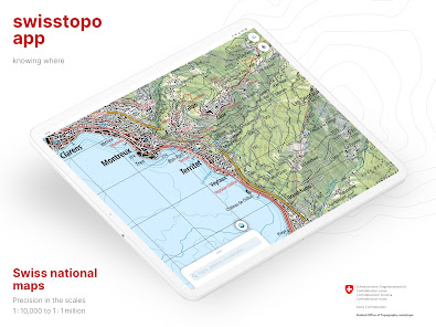
- all scales from 1:10 000 to 1:1 million
- current aerial image and historical maps
- official hiking, mountain hiking and alpine hiking trails
- closures of hiking trails
- snowshoe and ski routes
- SwitzerlandMobility routes
- public transport stops
ON THE ROAD
- free offline maps (1:25 000 to 1:1 million)
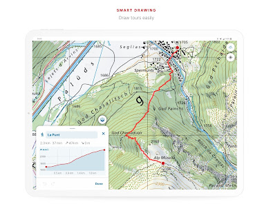
- draw, record, import and share your own tours
- set tour type (hiking, cycling, mountain biking) and personal pace
- tour guide (arrival time, remaining distance)
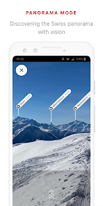
- panorama mode (labelled panorama, view tour in "3D")
- save markers, add notes, share
TOOLS such as measure, compare and search (for geographical names, addresses or coordinates)
Report changes to maps and geodata
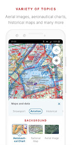
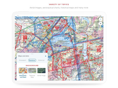
AVIATION
- aeronautical charts, obstacles, airspaces
- landing sites
- restrictions for drones and model aircrafts
Do you have a question? Then write to us:
[email protected]
Use the famous national maps to discover even the most remote places in Switzerland and topics such as hiking, cycling, snow sports and aviation. All functions and data of the app as well as offline use are free of charge. The app is free of advertising and does not require a login.
- all scales from 1:10 000 to 1:1 million
- current aerial image and historical maps
- official hiking, mountain hiking and alpine hiking trails
- closures of hiking trails
- snowshoe and ski routes
- SwitzerlandMobility routes
- public transport stops
ON THE ROAD
- free offline maps (1:25 000 to 1:1 million)
- draw, record, import and share your own tours
- set tour type (hiking, cycling, mountain biking) and personal pace
- tour guide (arrival time, remaining distance)
- panorama mode (labelled panorama, view tour in "3D")
- save markers, add notes, share
TOOLS such as measure, compare and search (for geographical names, addresses or coordinates)
Report changes to maps and geodata
AVIATION
- aeronautical charts, obstacles, airspaces
- landing sites
- restrictions for drones and model aircrafts
Do you have a question? Then write to us:
[email protected]
Updated on
Safety starts with understanding how developers collect and share your data. Data privacy and security practices may vary based on your use, region and age. The developer provided this information and may update it over time.

No data shared with third parties
Learn more about how developers declare sharing

No data collected
Learn more about how developers declare collection

Data is encrypted in transit
Ratings and reviews
4.7
2.31K reviews

Gedeon Stol
- Flag inappropriate
- Show review history
10 July 2022
Solid user experience and programming, this is how apps were supposed to be made. Includes offline maps, waypoint routing, storage and route tracking. No ads, no sneaky upsale strategy, no 3rd party tracking, no accounts to setup, just focused functionality, solid maps, and purpose. Thank you for making this.
11 people found this review helpful

l p
- Flag inappropriate
28 May 2024
This is the best hiking app for Switzerland. There are more hiking trails than in alltrails and komoot, route planning is extremely easy: it snaps to path, you can drag the route around, it displays all the usual statistics. Downloaded maps are available offline, you can import the hike into your usual hiking app if you want to keep your hikes history in one place. And it's free.
7 people found this review helpful

Nautilus (CptNautilus)
- Flag inappropriate
- Show review history
12 April 2024
I have been using this apps for years now. It used to be the best map app for Switzerland. I was using to prepare my trips at home (I have the paid version) and on the field. Alas, since the latest update, it makes my phone overheat to the point of burning my fingers and deplete the battery so fast that it has become useless in the field, where I can't recharge my battery and it has to last for the whole day. Samsung Galaxy S10, Android 10
2 people found this review helpful
Federal Office of Topography swisstopo
11 April 2024
Hello, the problem does not occur on all devices, we are trying to analyse it and would be grateful if you could let us know which functions you are using when the problem occurs. Also the details of the device type. Please send your feedback to [email protected], kind regards swisstopo
What's new
Take a journey through time with the swisstopo app: Over 180 years of Switzerland’s map history is now available on your smartphone. The base map also includes additional information on pharmacies and Swiss parks.
You have questions or feedback? Contact us by e-mail ([email protected]) or phone (+41 58 469 02 22).
You have questions or feedback? Contact us by e-mail ([email protected]) or phone (+41 58 469 02 22).
App support
About the developer
Bundesamt für Landestopografie
Seftigenstrasse 264
3084 Wabern
Switzerland
+41 79 794 03 97


