GeoMapa Rural
100K+
Downloads

PEGI 3
info


About this app
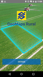
The Bank of Brazil provides support tool to farmers: the "Rural geo map" application for use on smartphones and tablets. It is an innovative solution to capture the coordinates (latitude and longitude) of the areas of rural property, which generates information necessary for contracting loans in BB, contributing to the gain agility and efficiency in the credit decision.
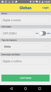
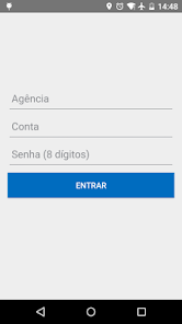
The application allows you to save the data for testing or validation of the area without the need for authentication. For sending information, login is allowed for both individuals and for corporations.
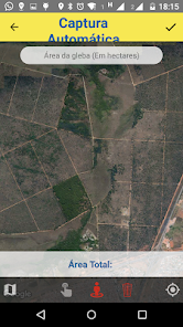
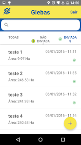
Are available 02 operational modes: Auto Capture - where the user makes the outline of the area and every 10 seconds the device's internal GPS scores a point; and Capture Manual - marking the points, on site, using the GPS function or with the help of a satellite map. This last option will only work with the existence of network and function of mobile data enabled device.
In addition, the web page "www.bb.com.br/agronegocios" features viewing features and printing of the polygon transmitted to BB with their coordinates. Here it is also possible to upload files .gpx, .kml and shapefile in .zip format.
The application allows you to save the data for testing or validation of the area without the need for authentication. For sending information, login is allowed for both individuals and for corporations.
Are available 02 operational modes: Auto Capture - where the user makes the outline of the area and every 10 seconds the device's internal GPS scores a point; and Capture Manual - marking the points, on site, using the GPS function or with the help of a satellite map. This last option will only work with the existence of network and function of mobile data enabled device.
In addition, the web page "www.bb.com.br/agronegocios" features viewing features and printing of the polygon transmitted to BB with their coordinates. Here it is also possible to upload files .gpx, .kml and shapefile in .zip format.
Updated on
Safety starts with understanding how developers collect and share your data. Data privacy and security practices may vary based on your use, region, and age. The developer provided this information and may update it over time.

No data shared with third parties
Learn more about how developers declare sharing

This app may collect these data types
Location and Device or other IDs

Data is encrypted in transit


