ALTLAS: Trails, Maps & Hike
Sadržava oglaseKupovina unutar aplikacije
4,1star
2,88 hilj. recenzijainfo
500 hilj.+
Preuzimanja

PEGI 3
info
O aplikaciji
🗺️ ALT-LAS: Trail Navigation & Activity Tracker
Your ultimate companion for outdoor adventures! Navigate trails, track activities, and explore new paths with precision elevation tracking and comprehensive mapping tools.
🎯 MAIN FEATURES:
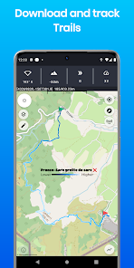
• Advanced GPS Navigation & Trail Mapping
• Precise Elevation Tracking with Dual-Mode Altimeter
• Comprehensive Activity Recording for Hiking, Cycling & More
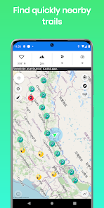
• Detailed Trail Database with User-Shared Routes
• Real-Time Weather Updates & Trail Conditions
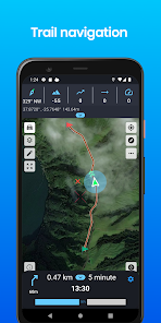
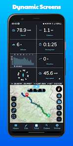
⚡ TRACKING & NAVIGATION:
• GPS and Barometric Altitude Tracking
• Offline Maps Support (Pro)
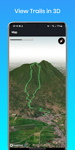
• 3D Trail Visualization (Pro)
• Live Location Sharing (Subscription)
• Import/Export GPX Files
• Multiple Map Types: Topographic, OpenStreetMap, Satellite (Premium)
• Real-Time Activity Stats
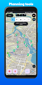
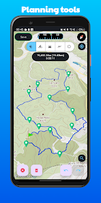
🎮 PLANNING TOOLS:
• Route Distance Calculator
• Vertical Distance Measurement
• Smart Routing Between Locations
• ETA Calculator
• Coordinate Finder
• Circular Boundary Tool
📱 SMART FEATURES:
• Accurate Indoor/Outdoor Elevation
• Dark Mode Support
• Weather Forecasts
• Compass with Bearing Lock
• Environmental Sensors (on supported devices):
- Barometric Pressure
- Temperature
- Light
- Humidity
💪 PERFECT FOR:
• Hiking & Trekking
• Mountain Biking
• Road Cycling
• Skiing
• Walking Tours
• Any Outdoor Adventure!
⚙️ TECHNICAL FEATURES:
1. GPS Mode: High-precision altitude measurement with smart correction
2. Barometer Mode: Indoor-capable altitude tracking using device sensors
✨ PRO FEATURES:
• Offline Maps
• 3D Trail Views
• Premium Map Types
• Live Location Sharing
🔔 SUPPORT & COMMUNITY:
• Active Telegram Community: https://t.me/ALTLASAPP
• Comprehensive Guide: https://altlas-app.com/support.html
• Direct Support: [email protected]
• Website: www.altlas-app.com
Note: Use of this app is at your own discretion.
❤️ Love ALTLAS? Please rate us and share your experience!
Your ultimate companion for outdoor adventures! Navigate trails, track activities, and explore new paths with precision elevation tracking and comprehensive mapping tools.
🎯 MAIN FEATURES:
• Advanced GPS Navigation & Trail Mapping
• Precise Elevation Tracking with Dual-Mode Altimeter
• Comprehensive Activity Recording for Hiking, Cycling & More
• Detailed Trail Database with User-Shared Routes
• Real-Time Weather Updates & Trail Conditions
⚡ TRACKING & NAVIGATION:
• GPS and Barometric Altitude Tracking
• Offline Maps Support (Pro)
• 3D Trail Visualization (Pro)
• Live Location Sharing (Subscription)
• Import/Export GPX Files
• Multiple Map Types: Topographic, OpenStreetMap, Satellite (Premium)
• Real-Time Activity Stats
🎮 PLANNING TOOLS:
• Route Distance Calculator
• Vertical Distance Measurement
• Smart Routing Between Locations
• ETA Calculator
• Coordinate Finder
• Circular Boundary Tool
📱 SMART FEATURES:
• Accurate Indoor/Outdoor Elevation
• Dark Mode Support
• Weather Forecasts
• Compass with Bearing Lock
• Environmental Sensors (on supported devices):
- Barometric Pressure
- Temperature
- Light
- Humidity
💪 PERFECT FOR:
• Hiking & Trekking
• Mountain Biking
• Road Cycling
• Skiing
• Walking Tours
• Any Outdoor Adventure!
⚙️ TECHNICAL FEATURES:
1. GPS Mode: High-precision altitude measurement with smart correction
2. Barometer Mode: Indoor-capable altitude tracking using device sensors
✨ PRO FEATURES:
• Offline Maps
• 3D Trail Views
• Premium Map Types
• Live Location Sharing
🔔 SUPPORT & COMMUNITY:
• Active Telegram Community: https://t.me/ALTLASAPP
• Comprehensive Guide: https://altlas-app.com/support.html
• Direct Support: [email protected]
• Website: www.altlas-app.com
Note: Use of this app is at your own discretion.
❤️ Love ALTLAS? Please rate us and share your experience!
Ažurirano dana
Sigurnost počinje razumijevanjem na koji način programeri prikupljaju i dijele vaše podatke. Privatnost podataka i sigurnosne prakse se mogu razlikovati ovisno o korištenju, regiji i dobi. Programer je naveo ove informacije i može ih s vremenom ažurirati.


Ocjene i recenzije
4,1
2,84 hilj. recenzija

Muki Mukki
- Označavanje kao neprikladno
- Prikaz historije recenzije
3. januar 2024.
This app is amazing. It literaly has every single path😂
Što je novo
Functionality:
Added grade calculator
AI assistant
Coordinate insertion
UI/UX Improvements:
Enhanced UI
Better metric view interface with updated icons
Bug Fixes:
Loading GPX files
Addressed POI-related bugs
Map selection view issues
Do you have any issues or suggestions? Please write to us at [email protected]. We appreciate your feedback!
Podrška za aplikaciju
Informacije o programeru


